When heavy snowfall blocks roads and extreme cold disrupts traditional transport, delivering supplies in high-altitude regions becomes extremely difficult. In areas like Ladakh and Siachen, freezing temperatures, strong winds, and thin mountain air create serious challenges for logistics operations, especially for a logistic drone in cold climate scenarios.
This is where modern logistics drones are making a difference. Designed for extreme environments, these drones can operate in snow, maintain stability in harsh Himalayan conditions, and support supply delivery in places where conventional transport struggles. However, flying in sub-zero temperatures also affects battery efficiency, motor performance, and overall flight stability.
This article explores how drones maintain reliable performance in extreme cold and snow, and high-altitude environments, and the technologies that make these missions possible.
Challenges of Flying Drones in Extreme Cold and Snow
Drones can operate in freezing temperatures and snowy conditions, but cold weather creates serious challenges for flight performance. Low temperatures reduce battery efficiency, shorten flight time, and can affect overall power delivery during missions.
Snow and moisture also create operational risks. Ice buildup on propellers can impact balance and stability, while freezing conditions place extra stress on motors and electronic systems. In high-altitude regions, thin air makes lift generation more difficult, forcing drones to work harder to maintain stable flight.
To manage these conditions, modern logistics drones are built with insulated battery systems, powerful propulsion units, weather-resistant components, and advanced flight control software. These features help maintain reliable drone cold weather performance, especially during high altitude drone logistics operations in regions such as Ladakh and Siachen.
How Sub-Zero Temperatures Impact Drone Cargo Capability
When temperatures drop below freezing, a drone’s ability to carry and deliver payloads is affected in more ways than just battery drain. Cold conditions influence lift generation, motor efficiency, and overall structural response during flight.
In sub-zero environments, batteries deliver lower peak power, which directly reduces thrust. Since drone payload capacity depends on available thrust, drones may not be able to carry their maximum load in extreme cold. Even a small reduction in power can force operators to lower cargo weight for safe and stable flight.
Air density also plays a role. While denser cold air can help lift in some cases, the combination of altitude and freezing temperatures often cancels out this advantage in mountainous regions. As a result, payload performance becomes less predictable in high altitude drone logistics missions.
To manage this, operators often reduce cargo weight margins and rely on drones designed specifically for drone extreme cold performance. These systems use high-torque motors, optimised propellers, and intelligent power distribution to maintain stability while carrying essential supplies in harsh environments.
What Happens to Propellers and Motors in Freezing Mountain Conditions?
In freezing mountain environments, propellers and motors are under constant stress due to ice formation, low temperatures, and high-altitude wind patterns. These factors directly impact stability, efficiency, and flight safety.
Key Impacts on Propellers and Motors
- Ice formation on propellers: Even a thin ice layer disrupts airflow, causing imbalance, vibration, and reduced lift.
- Reduced motor efficiency: Extremely low temperatures can increase lubricant viscosity and reduce motor responsiveness.
- Higher mechanical stress: Motors work harder to maintain thrust, especially during take-off and payload delivery.
- Instability in flight performance: Combined effects of ice, wind, and thin air increase vibration and reduce overall control accuracy.
These challenges are especially critical in drone flying in snow and high-altitude environments. To manage them, logistics drones are built with sealed motor systems, anti-icing protection, and durable composite propellers designed for consistent drone stability in Himalayan wind and snow during high altitude drone logistics missions.
How Logistics Drones Manage Battery Performance in Sub-Zero Temperatures
Battery performance is one of the most critical factors in cold-weather drone operations. In sub-zero conditions, lithium batteries naturally lose efficiency because the internal chemical reactions slow down. This results in reduced power output, shorter flight time, and in some cases, unstable voltage delivery during high-load operations. In some extreme environments, battery performance can decline by 20-50% if thermal management systems are not used.
In high-altitude and snowy environments, this challenge becomes even more significant. A drone that performs normally in moderate weather may see a noticeable drop in endurance when exposed to extreme cold. This directly affects payload capacity, range, and mission reliability during logistics operations.
According to Herewin, Drone battery efficiency can drop by 20-30% or more in freezing conditions, reducing flight time and payload performance if thermal management systems are not used.
Key Challenges in Cold Conditions
- Reduced energy output: Batteries deliver less usable power in freezing temperatures.
- Shorter flight duration: Overall endurance decreases due to slower chemical reactions.
- Voltage instability under load: Sudden power drops can affect flight stability during payload delivery.
- Slower recharge efficiency: Charging cycles take longer in low-temperature environments.
To overcome these limitations, modern systems use thermal battery management solutions. These include insulated battery compartments, built-in heating elements, and pre-warming procedures before flight. Some advanced platforms also monitor real-time battery temperature and adjust power consumption dynamically.
These technologies play a major role in improving drone cold weather performance, especially in demanding high altitude drone logistics missions where consistent energy delivery is essential for safe and reliable operations.
High-Altitude Performance in Cold Environments
Flying drones in high mountain regions like Ladakh and Siachen is not just about dealing with cold, it’s about handling thin air, unpredictable winds, and reduced lift at the same time. When temperature drops and altitude increases together, overall flight efficiency changes significantly.
Main Challenges
- Lower air density reduces lift, making it harder to stay airborne
- Higher motor load as drones push harder to maintain thrust
- Sudden wind shifts affect hovering and navigation stability
- Reduced endurance impacts range and payload capacity
How Drones Adapt
To handle these conditions, systems used in high altitude drone logistics are built with high-torque motors, efficient propellers, and lightweight structures. Flight controllers continuously adjust power output to maintain balance and ensure stable operation.
These design improvements are key to maintaining drone stability in Himalayan wind and snow, where both weather and altitude work against consistent flight performance.
Pre-Flight Checks for Extreme Cold Operations
Before a drone is launched in freezing conditions, preparation becomes just as important as the flight itself. In extreme cold environments, even a small oversight can affect performance, stability, or mission safety.
Operators working in high altitude drone logistics follow strict pre-flight procedures to ensure the system is ready for snow, wind, and sub-zero temperatures.
Essential Pre-Flight Checks
- Battery temperature readiness: Batteries must be warmed to an optimal operating range before take-off.
- Propeller and motor inspection: Check for ice buildup, cracks, or any moisture that could freeze mid-flight.
- Weather and wind assessment: Sudden changes in Himalayan weather can impact drone stability.
- Sensor and GPS calibration: Ensures accurate positioning in remote and high-altitude terrain.
- Payload balance verification: Improper weight distribution reduces control in thin air conditions.
These steps are crucial for maintaining reliable drone cold weather performance and reducing operational risks during drone flying in snow.
A properly prepared system significantly improves drone stability in Himalayan wind and snow, especially when missions involve critical deliveries in remote mountain regions.
How Drones Are Engineered for Himalayan Cold-Weather Operations
In regions like Ladakh and Siachen, logistics is not just about efficiency, it is often about access and survival. Roads can remain blocked for long periods, weather shifts quickly, and traditional transport methods are frequently delayed or restricted, making logistic drone in cold climate operations increasingly important.
This is why specialised drone systems are becoming increasingly important. Indian logistics drones for Himalayan operations are not standard commercial platforms. They are purpose-built for cold, high-altitude environments where temperature, terrain, and wind all create operational challenges.
What Makes These Systems Different
- Thermal protection for batteries and onboard electronics
- High-altitude propulsion systems for improved lift in thin air
- Reinforced airframes for rugged mountain conditions
- Navigation redundancy for weak or unreliable signals
- Stability in sudden gusts of wind with wind-adaptive flight control
These features enable reliable operations in areas where conventional transport struggles, strengthening high altitude drone logistics capabilities.
Beyond defence use, the same systems also support civilian needs. Remote villages, disaster-affected zones, and isolated settlements can benefit from faster and more consistent deliveries, especially during harsh winter months.
In such conditions, drone technology is becoming less of an innovation and more of a practical infrastructure layer.
Can Drones Replace Mules and Helicopters in Himalayan Supply Chains?
In regions like Ladakh and Siachen, logistics has traditionally depended on a mix of helicopters, road convoys, and even pack animals in difficult terrain. Each system works, but all are heavily affected by weather, altitude, and accessibility.
Drones are increasingly being integrated as a complementary logistics layer rather than a complete replacement for helicopters or ground transport. Helicopters are fast but expensive and weather-limited, while ground transport is reliable but slow and restricted by terrain. Drones help bridge this gap by handling quick, short-range deliveries of essential supplies.
Where drones are useful
- Faster delivery of urgent, lightweight cargo
- Better access to remote or hard-to-reach locations
- Lower cost for short-distance logistics missions
- Reduced dependence on weather-sensitive helicopter flights
That said, drones still have limits in payload capacity and range, so they cannot fully replace traditional systems. Instead, high altitude drone logistics is becoming part of a hybrid model where drones, helicopters, and ground teams work together.
This combination is improving response times and reliability in challenging mountain regions.
What Makes a Drone Suitable for Extreme Cold Operations?
Not all drones can handle freezing temperatures, strong winds, and high-altitude conditions. Only specially designed systems are capable of maintaining stable performance in such harsh environments.
Cold-weather drones rely on a combination of thermal protection, strong propulsion, and intelligent flight control to stay operational when conditions become unpredictable.
Key Requirements
- Battery systems that stay stable in sub-zero temperatures
- High-torque motors for lift in thin air
- Sealed components to protect against snow and moisture
- Durable airframes built for strong wind resistance
- Smart flight controllers for real-time stability adjustments
These features are essential for maintaining reliable drone cold weather performance in snow-covered and mountainous regions.
In high altitude drone logistics, success depends on how well a drone balances efficiency, stability, and environmental resistance in extreme conditions.
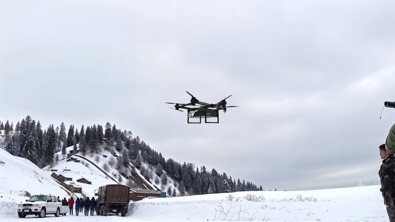
BonV Aero’s High-Altitude Logistics Achievement
At BonV Aero, we have demonstrated our drones’ capability in high-altitude operations through a record-setting mission in extreme Himalayan conditions. As a logistics drone manufacturing company, our focus is on designing, developing, and testing UAV systems built specifically for cold, windy, and high-altitude environments.
In this mission, our drone successfully operated in the Ladakh region (Himalayan terrain) at an altitude of approximately 18,000+ feet above sea level, carrying out a logistics delivery profile in thin air and sub-zero temperatures. The system maintained stable flight performance, reliable payload handling, and controlled navigation despite strong mountain winds and low air density.
This achievement highlights critical performance factors required in high altitude drone logistics, including endurance in extreme cold, thrust efficiency at high elevation, and consistent stability under rapidly changing weather conditions.
Through this record, We’re continues to demonstrate practical readiness for real-world deployment in some of the most challenging operational environments. More details of this milestone are covered in our breakdown of the high-altitude drone logistics record in Ladakh, where we explain the mission performance and outcomes in depth.
Extreme cold, snow, and high-altitude terrain push drone systems to their operational limits. Battery efficiency drops, lift becomes harder to maintain, and flight stability is constantly challenged by wind and thin air. Yet, with the right engineering and testing approach, drones are increasingly proving their value in these environments.

Rahul Kumar is Co-Founder of BonV Aero and an aeronautical engineer with deep expertise in design, simulation, and product development. A serial entrepreneur and mentor, he leads innovation in lightweight, efficient eVTOL structures.